Monday 28 January 2013

Sand and snow

This view is of Carl Wark (left) and Higger Tor still clinging to snow on their eastern slopes.


Friday 25 January 2013

Lead mining in the Peak District (4th edition)

T.D. Ford & J.H. Rieuwerts (2000) Landmark Publishing

Introduction: Geology

The common ores mined in the Peak District are GALENA (lead sulphide), SPHALERITE (zinc sulphide), FLUORITE (calcium fluoride), BARYTE (barium sulphate) and CALCITE (calcium carbonate).

RAKES are major veins formed in vertical fissures often 2-3 m wide but up to 15 m wide. They can be 4-5 km long and some have been mined to 200 m deep.

SCRINS are smaller versions of rakes not often more than 50 cm across and 1 km long.

FLATS are horizontal deposits laying parallel to the bedding.

PIPES are irregular deposits parallel to the bedding.

Pipes and flats are often close to or capped by thin volcanic deposits know as wayboards.

The mineral deposits were formed from hot fluids which came from 2-3 km below the surface and picked up minerals on the way. These were precipitated by cooling, mixing with cooler surface waters, reaction with sulphur compounds in pore waters or reaction with oxygen in such waters. This reached a climax at the end of the Carboniferous 270 million years ago.

Galena (PbS) is easily recognised by its silvery metallic lustre. Veins contained form as much as 10% to as little as 2%. The veins along the eastern margin of the mineral field also contained sphalerite (ZnS) recognised by its dark brown chocolate colour and also known as blende or blackjack. It had little value until brass (an alloy of zinc and copper) became popular in Victorian times. In a few areas the sulphides have been oxidised to carbonates, cerussite (lead carbonate) and smithsonite (zinc carbonate, commonly known as calamine). Cerussite is the raw material for white lead and several White Rakes are allegedly named after it. The gangue minerals of metal extraction were fluorspar, barytes and calcite. Nowadays these are the main products and metallic ores are byproducts. Fluorspar (CaF) is the chief source of fluorine for the chemical industry. It is largely confined to a 2 km wide strip at the eastern margin of the ore field. Baryte (BaSO4) and calcite (CaCO3) complete the 5 minerals which form the bulk of the mining activity in the Peak District.

This is followed by a comprehensive history of mining in the Peak District and then a list of itineries.

Itineraries:

1. Castleton

2. Peak Forest

3. Hucklow, Eyam, & Stoney Middleton Area

4. Sheldon & the Magpie Mine

5. The Ashford Black Marble Mines & Mill

6. The Lathkill Dale Mines

7. Hillocks & Knotlow Mines, Monyash

8. The Alport Mines

9. The Lead Mining Village of Winster

10. The Wensley-Darley Area & Mill Close Mine

11. The Matlock Area

12. Cromford & Bole Hill

13. Good Luck Mine, Middleton-By-Wirksworth

14. Wirksworth

15. Carsington Pasture & Brassington

16. The Crich Area

17. Stonedge Cupola, Ashover

18. The Ecton Copper Mines


Sunday 20 January 2013

January snow

The first snow of 2013 showing the Peak District sign just north of Ringinglow.


Saturday 19 January 2013

Gritstone edges

I sketched the relationship between the various gritstone edges using SketchBook Pro overlaying the OS map so that the relationships are to scale.

The main edges (Stanage to Gardom's) are of Chatsworth Grit (318-319 million years). White Edge and Birchen Edge are made of younger Crawshaw Sandstone (314-316 million years) while the lower Bamford Edge is of older Kinderscout Grit (319-321 million years).

Friday 18 January 2013

Eagle stone

SK263738

Eagle stone is a short walk from Curbar Gap carpark on Baslow Edge.


The geological history of the British Isles (part 2)

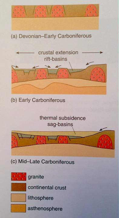
The Caledonian Orogeny produced highlands (Southern Uplands, Anglo-Brabant, Welsh) by crustal shortening and uplift. Post orogenic granite blocks such as the Alston and Askrigg were also emergent. These persisted while crustal extension in the early Carboniferous created a series of rift basins around them. When rifting slowed the thermal relaxation of the crust led to thermal sag basins.


The geological history of the British Isles (part 1)

To put the Carboniferous into context I re-read the Open University book in the title of the post. I possess no artistic skills at all but have drawn the following cartoons which shows the main stages with no reference to paleolatitude. They are obviously not to scale or the correct shape either!

Scotland and the rest of the British Isles are on different landmasses
Avalonia separates from Gondwana and begins its journey across the Iapetus
The Iapetus closes, the Rheic opens
Laurentia, Baltica and Avalonia collide in the Caledonian Orogeny as the Iapetus finally closes
The Rheic closes and Pangea forms in the Variscan Orogeny


Friday 11 January 2013

The Pennines and adjacent areas (Regional Geology Guides) Fourth Edition

N. Aitkinhead et al. (2002) British Geological Survey
Time to read the definitive guide to the geology of the Peak District and other Pennine regions.
Pre-carboniferous rocks. There are some outcrops of Ordovician and Silurian rocks in the Yorkshire Dales (near Ingleton, Horton-in-Ribblesdale and Malham) but non in the Peak District area. These have been shown to underlie the Peak District in borehole studies.
Dinantian deposits outcrop to the north of this region on the Askrigg block and Craven basin, and to the south as the Derbyshire dome. The Derbyshire dome consists of the Derbyshire and Staffordshire platforms separated by the Widmerpool Gulf. The Derbyshire platform deposits are from the ramp and shelf of the platform but not the slope and basin which outcrop to the south in the Widmerpool Gulf region.
Platform - thickly bedded, pale grey to grey, massive bioclastic limestones (packstones and grainstones), dolomitised limestone and dolomite. Woo Dale Limestones, Bee Dale Limestones and Monsal Dale Limestones.
Ramp - grey to dark grey, thinly bedded bioclastic limestones (packstones) commonly with chert nodules and pale grey micritic limestones forming knoll reefs (mud mounds).
The rocks of Namurian age form the continuous outcrop which forms the Pennines. It divides at the south of Edale to outcrop on either side of the Derbyshire Dome. Course grained to granular, feldspathic sandstones are the dominant characteristic of the Millstone Grit Group. Ashover Grit near Derby and Chatsworth Grit near Leek form the oldest rocks and overlie the Namurian mudstones of the Edale Shale Group (these also contain sandstones but their proto-quartzitic composition distinguishes them from the Millstone Grit Group).
The successions are of a remarkably cyclical nature marked by regular marine transgressions which define the base of each cycle. There are 46 + 3 more recent of these recognised. They were caused by the growth and decay of the Southern Hemisphere ices sheets.
The rocks are mostly formed from mud, silt and sand carried into the Pennine basin by a large river system from mountains in Scananavia and Greenland. The abundance of fresh feldspar show the erosion and rapid transport from granitic source. The sea level changes also controlled delta growth stopping as sea level rose, and starting again as it fell.
The lower Westphalian Coal Measures were laid down in the Pennine basin between the Southern Uplands High and the Wales-Brabant High. They were laid down as a continuous strata but the movements associated with the Variscan Orogeny in the late Carboniferous and early Permian deformed them into gentle folds. Erosion left only those in the downthrown areas intact. The outcrops are to the east and west of the Namurian sandstones and ad not well represented in the Peak District.
Limestone
The Carboniferous limestones of Derbyshire were famous as decorative stones, commonly termed 'marbles' by the trade because of their ability to take a high polish, their varied colours and attractive structure.They included the Ashford Black Marble, Birds Eye Marble. Rosewood Marble, Duke s Red and Muscle Marble. None of these stones are produced today, but they can be seen as decorative inlays in many of the great houses of Derbyshire such as Chatsworth, Hardwick and Bolsover Castle.Today, polished limestones are produced from the Bee Low Limestones at Hopton Wood and Griffeton Wood quarries. Hopton Wood Stone has been used in many major buildings, including the Bank of England and the city halls of Manchester and Sheffield. On a sombre note, the creamy grey, crinoidal Hopton Wood Stone provided the headstones for the graves of tens of thousands of British and Commonwealth troops who fell in the 1st and 2nd World Wars.
Sandstone
The exploitation of the Namurian sandstones in the Peak District also has a long history and all the major sandstones have been quarried for building stone. In the High Peak area sandstones of the Shale Grit (at Kinder Bank), Kinderscout Grit (at Chinley Moor, Ladybower and Hayfield), the Heyden Rock (at Thornseat), Roaches Grit (at Combs, Ridge Hall and Longhill), Chatsworth Grit (at Birch Vale and Buxworth) and the Rough Rock (at Cracken Edge) have all been extensively worked. The most important area of sandstone quarrying in Derbyshire lies farther south and east along the Derwent and Amber valleys and the intervening hillsides, where the Namurian sandstones crop along the valley sides from Hathersage to Belper. Quarries have long worked the Kinderscout Grit at Stokehall quarries),the Asbover Grit (at Darley Dale, Birchover, Duke's, Whatstandwell and Stanton quarries), and the Chatsworth Grit (at Yarncliff, Beeley Moor, Bole Hill, Lumshill and Millstone Edge quarries). The Rough Rock from the Coxbench quarries was used extensively for buildings in Derby.The Stancliff Darley Dale Stone is particularly famous for its durability and quality and has been widely used in towns and cities (for example Derby Cathedral, the Guildhall in Nottingham). The Ashover Grit used in buildings in the village of Kirk Ireton is stained pink by percolation of groundwaters through the former Triassic red-bed cover. The Shale Grit was used for the Kinder Reservoir and ’Stokehall Stone’ from Grindleford for the Howden and Derwent Reservoirs and Sheffield Town Hall.
Lead
Lead sulphide mineralisation (galena. PbS) has been worked in the area from large numbers of veins.There are several hundred named veins and many small, unnamed ones.They are up to several kilometres long, less than 10 m wide, of limited vertical extent and steeply dipping and consist of galena, fluorite, calcite and baryte.The major veins are commonly known as 'rakes', the minor ones as 'scrins'. Fluorspar and baryte have also been worked in more recent years and are now the main economic minerals recovered; no veins are now worked solely for lead. Semi-concordant 'flats' have also been worked as at Masson Hill near Bonsall. A few short, tubular, subhorizontal pipe oreshoots also occur, as at Hubberdale pipe.The mineralisation is largely confined to the eastern half of the exposed Dinantian limestone outcrop and is mainly hosted within the Monsal Dale Limestones, where overlying Namurian shales formed an impermeable caprock to the mineralising solution. The most important deposit was at the Millclose Mine near Darley Dale, where over 400 000 tonnes of lead concentrate and 90 000 tonnes of zinc concentrates were recovered from a remarkable orebody where natural concentration of galena in a cave system produced very high grades of mineralisation. Elsewhere in the orefield, the grades were about 5 per cent Pb, the exact figure dependent on the width of vein worked. Modern exploration has continued to develop the orefield, with the emphasis on fluorspar. In the early 1950s, there was an attempt to further develop the Riber Mine on the Great Rake for lead and zinc. Initial boreholes showed promising widths and is of lead mineralisation. However, subsequent underground development showed that miners had removed much of the mineral and that the boreholes had fortuitously through unworked pillars, giving a false impression of the possible resources left in the vein. The mine was closed in 1958. Calcite production continues from the Long Rake vein in the centre of the orefield.
This is very much just the highlights of the book. I expect I will be returning to this book again and again as the journey continues.

Friday 4 January 2013

Soil indicator plants


Trees and shrubs

Alder  

*Wet, usually beside a stream or river. Indicates land liable to flood
Beech
Well-drained; often suffers from die-back on poorly-drained soils
Bilberry
*Acid, *poor
Bramble
Well-drained but moist
Bog-myrtle
*Wet, acid
Broom
Acid, sandy
Chestnut, sweet        
Acid, sandy, but often planted on other soils
Elder
Rich, usually alkaline
Elm, suckering
Very typical of clay, but in some areas also on sandy, gravelly soil
Elm, wych
Alkaline, often on a clay over limestone
Gorse, common
Well drained usually sandy, poor; but increasingly found on a wider range of soils
Gorse, dwarf and western
Acid, not necessarily well drained
Guelder rose
Moist to wet, usually alkaline
Heath, cross leaved
*Acid, poor, wet
Heather, bell
*Acid, poor, dry
Heather, common or ling
*Acid, poor, moist
Old man’s beard or wild clematis
*Alkaline
Rhododendron
*Acid
Rowan
Typical of light acid soils but also very occasionally on limestone
Scots pine
Acid, but often planted on other soils
Spindle
Alkaline
Wayfaring tree
*Alkaline
Whitebeam
Well drained, limestone or light sands
Willows, except goat willow
Wet
Yew
Especially common on chalk but also on other well-drained soils

Herbaceous

Agrimony
Well drained
Birdsfoot trefoil
Low nitrogen
Bog asphodel
Wet, *acid, *poor
Bracken
*Well-drained, usually acid, usually sandy when abundant
Buttercup, bulbous
Well-drained
Buttercup, creeping
Moist, compacted or heavy
Buttercup, meadow
Moist
Chickweed
Rich
Coltsfoot
Heavy
Cow wheat, common and small
Acid
Corn spurrey
Poor, acid
Cuckoo flower or Lady’s smock
Moist
Dead nettle, white and red
Rich
Dock, broad leaved
*Rich
Fat hen
Rich
Fleabane
Damp
Foxglove
Acid
Goosegrass or cleavers
Rich
Harebell
Well-drained
Heath bedstraw
Acid
Hemp agrimony
Damp to wet
Horseshoe vetch
*Alkaline, * dry; limestone or chalk
Horsetail
Wet subsoil
Kidney vetch
Well drained, usually alkaline
Marjoram
Well drained, usually alkaline
Meadowsweet
Moist to wet
Nettle, annual or small
Rich
Nettle, stinging
*Rich, especially in phosphorus
Opium poppy
Rich
Orache
Rich
Pineapple weed
Compacted
Plantain, greater
Compacted
Pyramidal orchid
Alkaline
Ragged robin
Wet, not very acid
Reed
Usually on soil flooded for at least part of the year
Rush, hard
*Wet, alkaline
Rush, soft
*Wet, acid
Salad burnett
Alkaline, dry
Sheep’s sorrel
*Acid, dry
Silverweed
*Compacted or damp
Sorrel, common
Poor
Stinking iris
Alkaline
Thistle, creeping
Often compacted subsoil, fairly rich
Thyme
Dry, usually alkaline
Tormentil, common
Acid, poor
Willowherb, great hairy
Damp
Wood sorrel
Usually acid